Harnessing the Power of Big Data with Geospatial Mapping At the Esri User Conference 2015 today, Esri and SAP announced that they are extending their existing alliance to allow Esri desktop software users to create, read, update or delete data that resides in the SAP HANA database, while making it simpler to embed Esri geospatial […]

Harnessing the Power of Big Data with Geospatial Mapping

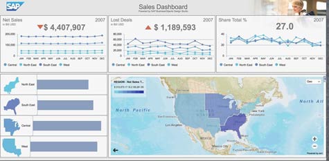
At the Esri User Conference 2015 today, Esri and SAP announced that they are extending their existing alliance to allow Esri desktop software users to create, read, update or delete data that resides in the SAP HANA database, while making it simpler to embed Esri geospatial data in a variety of SAP applications.
Geospatial data includes location-based data across a broad range of applications, and it is becoming more widely used. IT organizations don’t want to have to maintain an entirely separate database to support a single class of data. As such, SAP, via service pack 10 for HANA, embedded additional support for geospatial data directly into the SAP in-memory computing platform.
Nic Smith, senior director of product marketing at SAP, says Esri and SAP are now extending that capability out to Esri ArcGIS for Desktop, which is a desktop application used to edit geospatial data. At the same time, SAP has integrated Esri ArcGIS with SAP Lumira, the data visualization software that SAP is embedding within its broader application portfolio. It has also added a layer of Esri integration to SAP Mobile Work Manager, which is a field service application.

SAP is also geo-enabling SAP Business Suite, which will allow users of the company’s ERP applications running on SAP HANA to invoke a set of GEO.e services without requiring IT organizations to set up a separate database to handle that class of data.
Put it all together and it’s apparent that SAP is facilitating much deeper levels of data visualization across its application portfolio. The difference now is that not only will it be less costly to embed geospatial data in applications, but also most of that data will be available in real time using an in-memory computing platform.
MV
Michael Vizard is a seasoned IT journalist, with nearly 30 years of experience writing and editing about enterprise IT issues. He is a contributor to publications including Programmableweb, IT Business Edge, CIOinsight and UBM Tech. He formerly was editorial director for Ziff-Davis Enterprise, where he launched the company’s custom content division, and has also served as editor in chief for CRN and InfoWorld. He also has held editorial positions at PC Week, Computerworld and Digital Review.


