

Harnessing the Power of Big Data with Geospatial Mapping
![]()
A year after first promising to bring the geospatial technologies created by Esri to the SAP HANA in-memory computing platform, the two companies announced today the general availability of their joint effort.
At the Esri User Conference today, Ashish Sahu, director of SAP HANA Predictive, Text and Spatial Analytics, said the ability to run Esri geospatial applications directly on top of HANA will enable IT organizations to run these types of applications in real time. For example, geospatial data can now be more easily embedded within a business process.
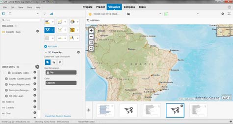
SAP also announced that the alliance with Esri includes the integration of geospatial analytics provided by ArcGIS Online from Esri within SAP Lumira data visualization tools.
Other areas in which the two companies are integrating their respective wares include: Galigeo BI for Location Analytics for SAP BusinessObjects Web Intelligence software, Integeo Map Intelligence for SAP BusinessObjects Web Intelligence, Centigon CMaps Analytics and Esri Maps for SAP BusinessObjects BI.
As processing power has become less expensive, geospatial analytics has increasingly been embedded in a much wider range of applications to give users an added dimension of time and space. Sahu says moving the processing of geospatial analytics into memory means that this capability can now be accessed in real time to give users access to the latest data.
From an IT perspective, that also means that IT organizations won’t have to set up separate database infrastructure to process geospatial data.
A direct correlation lies between the quality of the data visualization tool in an application and its ultimate value to the business. An application that makes it easy for end users to visually identify patterns and relationships is likely to be used a lot more often than one that doesn’t. The degree to which that data needs to be accessed in real time may be debatable. But the need to provide some type of geospatial analytics functionality has already become a standard application requirement.